
QGIS, a leading open-source Geographic Information System (GIS) platform, continually evolves through its robust plugin ecosystem. From enhancing data manipulation to integrating advanced geospatial analyses, the latest plugins released between January 2024 and June 2024 showcase significant innovations. This article provides a comprehensive overview of these new QGIS plugins, highlighting their features and potential applications
Power Clipboard by Łukasz Świątek

Purpose: Simplifies copying and zooming to coordinates.
Features: Four buttons to quickly copy or zoom to coordinates in XY/YX format. Supports multiple separators: tabulation, space, or comma. Automatically adjusts the decimal separator based on locale settings. This plugin enhances productivity by streamlining the process of working with geographic coordinates, making it easier for users to navigate and manipulate spatial data.
Pan Europeo by Fernando Badilla Veliz - Fire2a.com
Purpose: Generates qualitative summary rasters from large datasets.
Features: Processes approximately 30 rasters at 100m resolution (~30 GB of data). Allows users to define relative weight, utility attributes, and resampling methods. Includes target precision configuration for efficient data handling. Ideal for large-scale environmental and land-use studies, this plugin facilitates complex raster data analysis and visualization.
Trainminator2 by IGN

Purpose: Labeling tool for semantic segmentation and change detection in remote sensing.
Features: Supports single-date or bi-date labeling. Enhances geomatics and remote sensing workflows by providing advanced image classification tools. This plugin is crucial for researchers and analysts involved in monitoring and mapping changes in land cover and land use.
Band Stacker by Mirjan Ali Sha

Purpose: Stacks bands from selected raster layers.
Features: Simplifies the process of creating multi-band rasters. Useful for remote sensing specialists, this plugin facilitates the combination of various spectral bands into a single composite image for enhanced analysis.
CartoGrapher by Anqi Ouyang, College of Geographic Information Science, Jilin University

Purpose: Generalized map creation.
Features: Provides tools for cartographic design and map generalization. This plugin supports the creation of high-quality maps, catering to cartographers and GIS professionals.
Swiss GeoAdmin Bulk Geocoder by Niklas Vogel, Felix Reiniger, Stefan Keller

Purpose: Bulk geocoding for Swiss addresses.
Features: Uses geo.admin.ch service for geocoding. Adds coordinates to address attributes in a vector layer. Essential for projects involving extensive address data in Switzerland, this plugin streamlines the geocoding process.
EDAC Tools by EDAC dev team

Purpose: Collection of Python-based geospatial tools.
Features: Requires external libraries (geopandas, shapely). Offers solutions for various data analysis tasks. This toolbox is beneficial for users needing advanced data manipulation and analysis capabilities.
CompareClasseA by Vincent Bénet

Purpose: Compares two datasets of GPKG pointZ geometry based on French legislation.
Features: Ensures data compliance with French Class A standards. Ideal for geospatial professionals working with regulated datasets in France.
Stats By Polygon by Murat Çalışkan
Purpose: Generates statistics for raster bands based on polygon features.
Features: Creates detailed statistical summaries for spatial analysis. This plugin aids in deriving insights from raster data, crucial for environmental and agricultural studies.
UMap by IIC Technologies

Purpose: Transforms bathymetric data into community maps.
Features: Facilitates visualization and use of bathymetric data. This plugin democratizes access to bathymetric information, enhancing marine and coastal research.
SkyGIS by Asteria

Purpose: Integrates SkyDeck web application with QGIS.
Features: Allows data import from SkyDeck to QGIS. Enables GIS operations and updates back to SkyDeck. This integration enhances the versatility of SkyDeck data within the QGIS environment.
Amazon Location Service Plugin by Amazon

Purpose: Adds location functionality to applications.
Features: Supports maps, geocoding, routing, tracking, and geofencing. Prioritizes data security and user privacy. This plugin extends QGIS capabilities with robust location services, beneficial for developers and GIS analysts.
UA Coordinates Transformation by Bohdan2505

Purpose: Transforms coordinates within Ukraine.
Features: Supports SK-63, SK-42, USK-2000 systems. Uses the official State Geodetic Network API. This plugin is essential for geospatial projects in Ukraine, ensuring accurate coordinate transformations.
GeoBasis_Loader by GeoBasis_Loader

Purpose: Simplifies adding WMS/WFS services and background maps.
Features: Provides a nationwide collection of GeoBasis data. Ideal for users needing quick access to up-to-date geospatial services and maps.
Viper (QGIS Snake Clone) by Viper MiniQ

Purpose: Snake game clone using QGIS canvas.
Features: Interactive and educational tool using vector layer geometries. This plugin adds a fun and engaging way to interact with spatial data.
CIGeoE Series by Centro de Informação Geoespacial do Exército
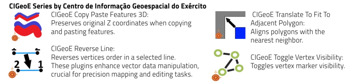
These plugins enhance vector data manipulation, crucial for precision mapping and editing tasks.
S2 Toolkit by Mikhail Melnikov, Oleg Petrov

Purpose: Creates S2 Geometry in QGIS.
Features: Currently includes “S2 From Extent” tool. Future updates will add more tools. This plugin expands QGIS’s capabilities in handling S2 geometries, essential for advanced spatial analyses.
PL-2000 by Szymon Kędziora

Purpose: Satellite measurements with ASG-EUPOS reference stations in Poland.
Luftbildfinder NRW by Kreis Viersen

Purpose: Loads aerial images for North Rhine-Westphalia, Germany.
Features: Available in German language only. This plugin provides easy access to regional aerial imagery, beneficial for local planning and analysis.
Conclusion
The latest QGIS plugins demonstrate the platform’s continuous innovation and responsiveness to user needs. Whether enhancing data manipulation, integrating new services, or providing advanced analytical tools, these plugins expand QGIS’s functionality, making it an indispensable tool for geospatial professionals worldwide. As these plugins become more widely adopted, they will undoubtedly contribute to more efficient and effective geospatial analysis and decision-making.