
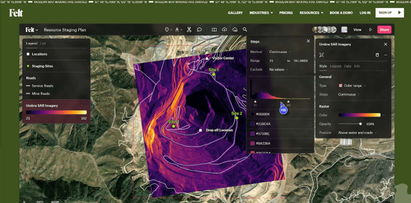
In the ever-evolving landscape of geospatial software, Felt has emerged as a challenger, promising an intuitive and collaborative mapping experience. But can it truly compete with established players, especially for users who rely heavily on QGIS, the popular open-source desktop GIS software? This in-depth review explores Felt’s strengths and weaknesses to determine if it deserves a place in your mapping toolkit.
Effortless Data Ingestion: A Breath of Fresh Air
Felt sets itself apart with its remarkable ability to handle a vast array of data formats. Gone are the days of struggling with restrictive file types. Felt embraces the “Upload Anything” philosophy, seamlessly integrating vector shapes (ESRI Shapefiles, GeoJSON, GeoPackages, KMLs), raster imagery (aerial and satellite imagery, digital elevation models), spreadsheet data (CSV, Excel, Numbers), and even GPS data formats (GPX, TCX, FIT).
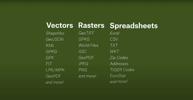
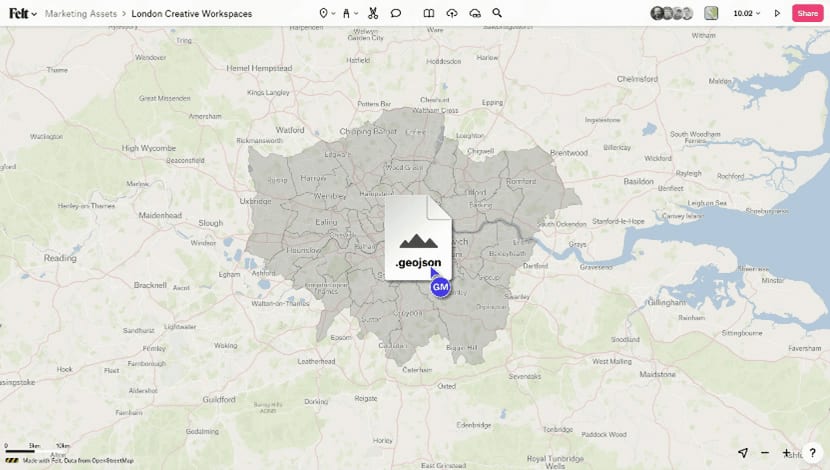
Importing data is refreshingly straightforward – a simple drag-and-drop, URL paste, or the dedicated QGIS plugin for effortless integration from your desktop GIS software. This plugin acts as a bridge, allowing you to seamlessly transfer layers and elements created within your QGIS project directly into your Felt map. QGIS users will appreciate this smooth workflow, eliminating the need for data conversion or reformatting. Felt boasts impressive file size support, accommodating datasets up to 5 gigabytes, catering to users working with large-scale geospatial information.
Visualization Powerhouse: From Simple to Sophisticated
Felt’s interface prioritizes user-friendliness, making map creation an accessible process. The intuitive style editor empowers users to craft visually appealing maps in just a few clicks. Choose from heat maps, categorical color-coded representations, or sized elements to effectively communicate patterns and trends within your data. Customization options abound, allowing you to refine the appearance of points, lines, and polygons for a polished look. Label and popup configurations are easily adjusted to ensure clarity and enhance user comprehension.
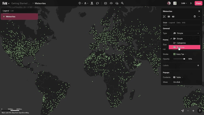
Fig 3: Map customization
For users demanding more than basic visualization, Felt caters to power users as well. Advanced options enable in-depth analysis of raster data, unlocking valuable insights from satellite imagery and elevation models. Utilize tools for highlighting, visualization, and data extraction to glean hidden patterns and inform decision-making. The ability to customize legend placement, color schemes, and thematic layers further enhances the map’s communicative power, making it a versatile tool for both beginners and advanced users.
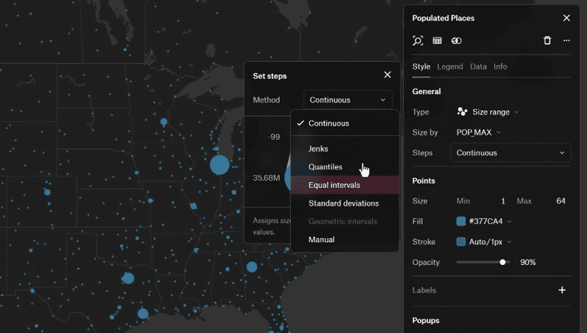
Fig 4: Fine-tuned point data
Collaboration Streamlined, But Not Yet Flawless
Felt fosters a collaborative environment with its suite of annotation tools. Highlight key areas, add notes, draw routes, and even extract buildings and boundaries directly from the base map for a truly interactive experience. Enrich your maps with context by embedding videos, linking to relevant websites, or leveraging Felt’s built-in library of datasets. Collaboration features like granular permission control, comment-driven discussions, and well-organized workspaces streamline project management.
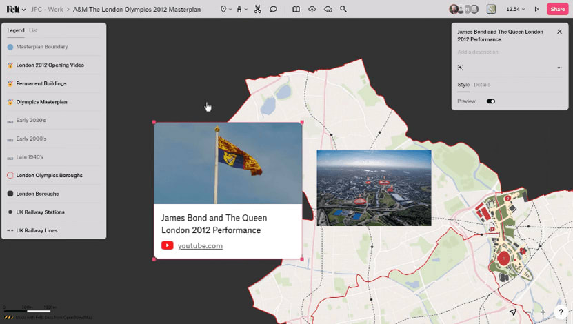
Fig 5: Embedded YouTube video
However, it’s important to note that some users might find the commenting system lacking compared to more mature mapping platforms. Real-time collaboration could be further enhanced by features like simultaneous editing or user presence indicators. Despite these minor shortcomings, Felt’s collaboration tools are robust enough to facilitate teamwork across different geographic locations, making it a valuable asset for remote teams and large organizations.
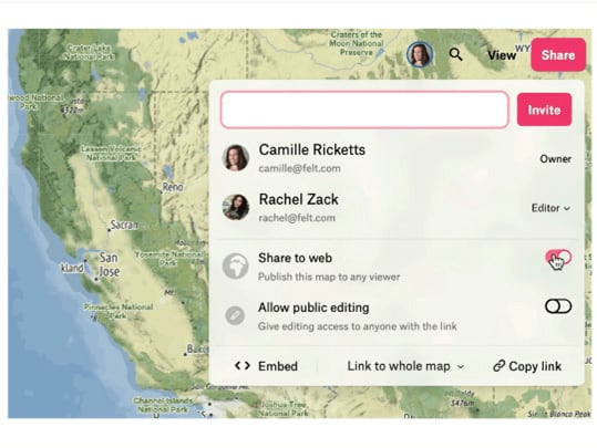
Fig 6: Member permission control
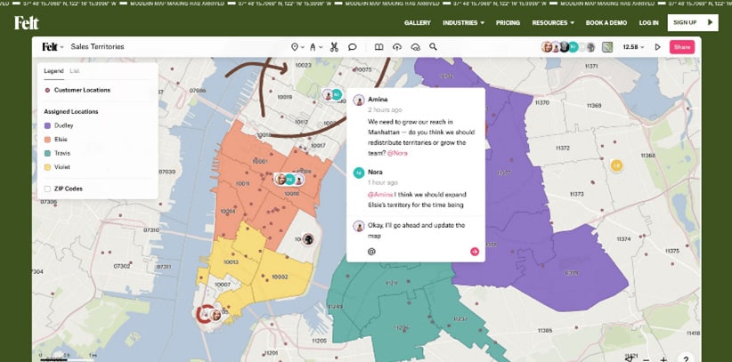
Fig 7: Members collaboration during fieldwork
Flexibility and Integration: Master of Collaboration
Felt integrates seamlessly with existing GIS tools, particularly QGIS, through a user-friendly plugin. This plugin fosters a smooth workflow between the two platforms.
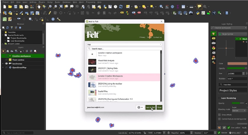
Fig 8: QGIS add to felt Plugin
Felt also functions admirably as a standalone application. Developers can leverage the Felt API for programmatic work with maps and perform advanced integrations. While the API offers robust functionality, the documentation might feel limited for highly experienced developers seeking extensive customization options.
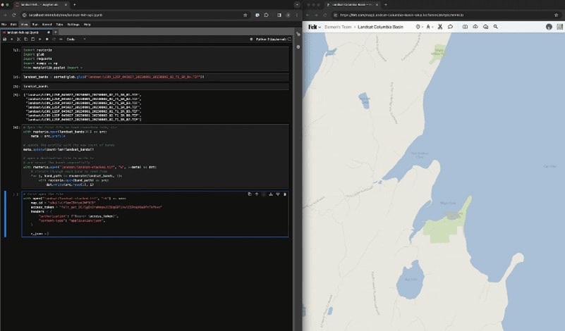
Fig 9: Felt developers interface
Where Felt truly shines is in its collaborative capabilities. The platform integrates seamlessly with various cloud storage providers, allowing multiple users to work on the same map simultaneously, even if they are not using QGIS. This makes Felt ideal for teams working on shared projects across geographical boundaries. Moreover, the ability to export maps in various formats ensures compatibility with other GIS applications and platforms, further enhancing its flexibility.
Speed and Aesthetics: A Winning Combination in Felt
Felt excels in performance. Data loads quickly, ensuring a smooth workflow. Maps render in a flash, minimizing wait times and maximizing productivity. The platform prioritizes aesthetics with default map styles that are presentation-ready, showcasing your data in a visually compelling manner. The high-quality rendering ensures that maps not only look good on screen but also in print, making it a reliable choice for creating professional-grade maps for reports, presentations, and publications.
Taking Control of the Narrative: Style Your Map Your Way
Felt empowers you to set the perfect stage for your map with a variety of base map options. Choose from classic views, explore satellite imagery, or upload your own custom base map to match the specific needs of your project. This level of customization allows you to tailor the visual foundation of your map to effectively communicate your message. Advanced users can even overlay multiple base maps to create unique, hybrid views that highlight different aspects of the data, enhancing the storytelling potential of the map.
Advanced Spatial Analysis in Felt 2.0
For users requiring in-depth spatial analysis, Felt 2.0 offers a powerful toolbox. Generate bounding boxes and buffer zones to analyze spatial relationships. Extract centroids, clip features based on specific areas, calculate point distribution, dissolve polygons to simplify complex datasets, identify overlapping features for spatial queries, and create masks to highlight specific regions of interest. These tools empower you to unlock deeper insights from your geospatial data and support informed decision-making.
Felt 2.0 also introduces machine learning capabilities for predictive analysis, enabling users to model future trends based on historical data. This feature is particularly useful for urban planners, environmental scientists, and disaster response teams who need to anticipate changes and prepare accordingly.
Enhancing User Experience with Training and Support
Felt understands that user experience goes beyond the software itself. The platform offers a comprehensive support system, including detailed documentation, video tutorials, and live webinars. New users can quickly get up to speed with step-by-step guides, while advanced users can delve into more complex features through specialized training sessions. The active user community and dedicated support team are always available to assist with any issues, ensuring that users can fully leverage the platform’s capabilities.
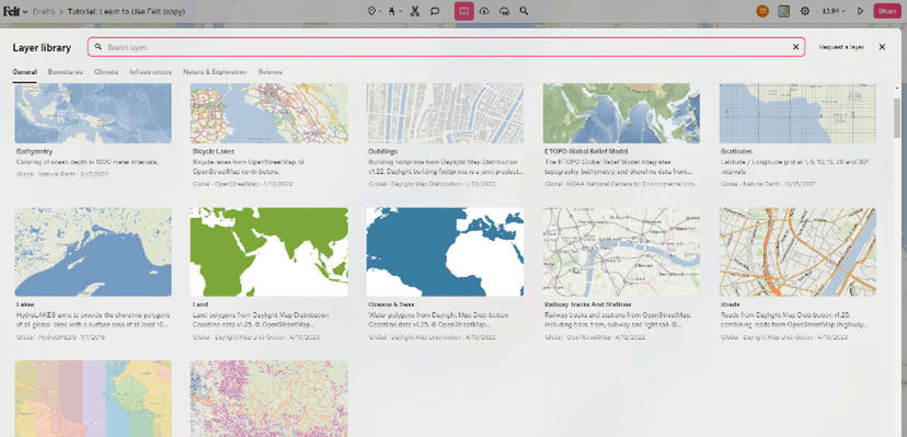
Fig 10: Inbuilt layer library
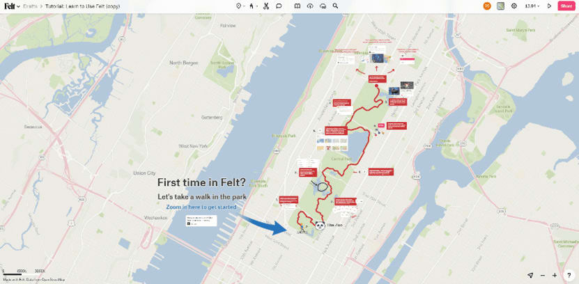
Fig 11: Learn to use felt tutorial
Comparing Felt with Other GIS Solutions
While Felt brings many innovative features to the table, it’s essential to consider how it stacks up against other GIS solutions, particularly for QGIS users. QGIS, known for its extensive range of plugins and advanced analytical capabilities, remains a powerhouse in the GIS community. However, Felt’s strength lies in its user-friendly interface and collaborative features, which make it more accessible to non-specialists and teams.
For users who require deep analytical tools and extensive customization, QGIS remains the go-to choice. However, for projects that emphasize collaboration, ease of use, and quick turnaround times, Felt provides a compelling alternative. The two platforms can complement each other, with QGIS handling the heavy analytical work and Felt facilitating the collaborative and presentation aspects.
The Future of Felt: Upcoming Features and Improvements
Felt is continuously evolving, with the development team actively working on new features and improvements based on user feedback. Upcoming updates are expected to include enhanced real-time collaboration tools, more advanced spatial analysis capabilities, and expanded support for additional data formats. The introduction of mobile app support will further extend Felt’s accessibility, allowing users to create and edit maps on the go.
The Verdict: Is Felt Worth It for QGIS Users?
Felt is a robust mapping tool that offers impressive data ingestion, powerful visualization, and seamless collaboration. While it may not yet fully replace QGIS for highly specialized GIS tasks, it provides a complementary platform that enhances team collaboration and simplifies the map-making process. The ease of integration with QGIS, combined with Felt’s user-friendly interface and extensive customization options, makes it a valuable addition to the geospatial toolkit of any mapping enthusiast or professional. Whether you are creating maps for presentations, conducting spatial analysis, or collaborating with a team, Felt offers a compelling blend of performance, flexibility, and aesthetic appeal that is hard to overlook.
In summary, Felt stands out as a versatile and powerful mapping solution that caters to a broad range of users. Its bias on collaboration, ease of use, and visual appeal makes it particularly suited for projects that require teamwork and clear communication. As Felt continues to evolve and expand its feature set, it is poised to become an indispensable tool for geospatial professionals and enthusiasts alike.