Malaria continues to cast a long shadow over Kenya, a nation where this mosquito-borne disease claims thousands of lives each year and disproportionately affects vulnerable populations like children and pregnant women. Despite ongoing efforts with tools such as insecticide-treated bed nets (ITNs) and public awareness campaigns, the fight is far from over. A groundbreaking study published in 2024 sheds new light on the spatial and temporal patterns of malaria risk across the country, revealing why certain regions remain hotspots and how environmental factors play a pivotal role. By analyzing national survey data and climate information, researchers have mapped out suitability zones for malaria transmission, offering valuable insights for policymakers and health workers aiming to curb this persistent threat.
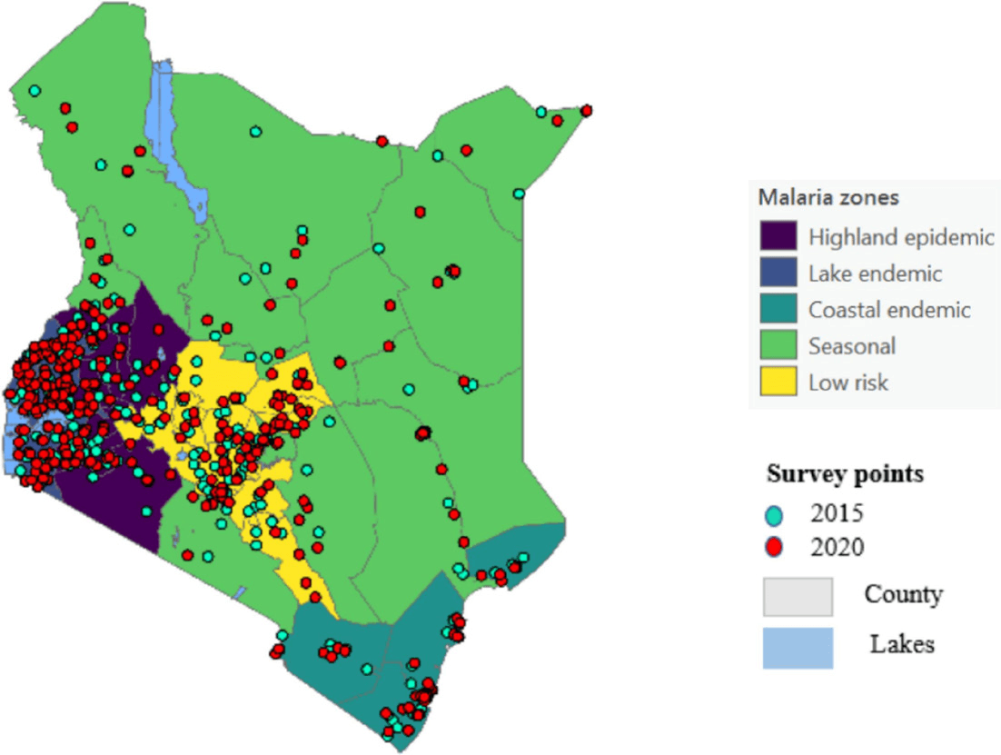
The study draws from the Kenya Malaria Indicator Surveys (MIS) conducted in 2015 and 2020, which involved large-scale data collection from thousands of households. In 2015, the survey sampled 10,072 individuals, while the 2020 edition expanded to 11,549 participants. These surveys, part of a broader effort by the Demographic and Health Surveys (DHS) program, focused on school-aged children under 15 and women aged 15-49, using rapid diagnostic tests (RDTs) and microscopy to detect malaria parasites. Geographical coordinates were recorded via GPS, allowing for precise spatial analysis. Complementing this, climate data from 22 weather stations sourced from the National Centers for Environmental Information (NCEI) provided details on precipitation and temperature, key drivers of mosquito breeding and malaria spread.
What emerges from this research is a stark picture of uneven malaria distribution across Kenya's diverse landscapes. The country is divided into five epidemiological zones: lake endemic, coastal endemic, highland epidemic, seasonal, and low-risk areas. Alarmingly, 79% of all malaria cases documented in the surveys were concentrated in the lake endemic zone, which surrounds Lake Victoria and includes counties like Kisumu, Siaya, and Homa Bay. This region, characterized by high humidity and consistent rainfall, proved to be 94% suitable for malaria transmission based on geospatial modeling—far higher than other zones. In contrast, the coastal endemic zone accounted for 11% of cases, the highland epidemic zone 7%, and the seasonal zone just 3%. These figures highlight how geography amplifies risk: warmer, wetter areas foster Anopheles mosquitoes, the vectors of Plasmodium parasites, leading to year-round transmission in endemic spots.
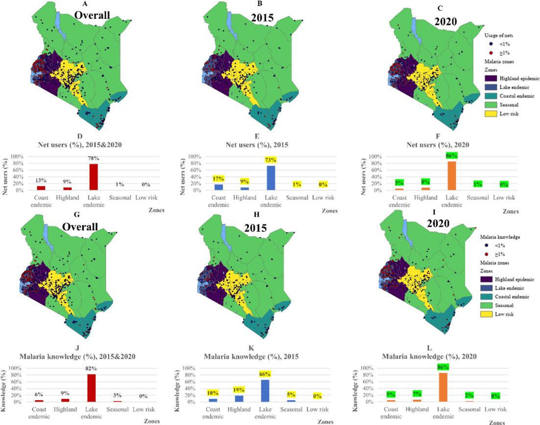
Interventions like ITNs have been a cornerstone of Kenya's malaria control strategy, with the government and international partners distributing millions of nets. The study found that ITN usage mirrored the disease burden: 77% of net use occurred in the lake endemic zone, 13% in coastal areas, 9% in highlands, and a mere 1% in seasonal zones. Similarly, knowledge and awareness about malaria—encompassing symptoms, prevention, and treatment—were highest in the lake endemic region at 82%, dropping to 9% in highlands, 6% in coastal zones, and 3% in seasonal areas. Yet, despite these high levels of adoption and education, malaria persists. The researchers point out that over 3.5 million new clinical cases and 10,000 deaths are reported annually in Kenya, underscoring gaps in implementation. Factors such as inconsistent net use, resistance in mosquitoes to insecticides, and socioeconomic barriers may be at play.
To delve deeper into environmental influences, the study employed advanced geospatial techniques, including the Fuzzy overlay method and kriging interpolation. Fuzzy overlay, a GIS tool, assesses suitability by combining multiple variables like temperature (optimal for mosquitoes between 16-35 Degrees Celsius) and precipitation (above 80mm monthly supports breeding). This modeling revealed that the lake endemic zone's climate creates near-ideal conditions for transmission, with suitability scores dwarfing those in drier or cooler regions. Kriging helped interpolate data points across unsampled areas, producing risk maps that visualize hotspots. Such maps are crucial for targeted interventions, allowing health authorities to prioritize resources—perhaps intensifying net distribution or spraying in high-suitability counties.
The implications of these findings are profound for Kenya's national malaria strategy, which aims to reduce incidence and mortality by 75% from 2016 levels by 2023—a goal that has faced setbacks due to the COVID-19 pandemic and climate change. Rising temperatures and erratic rainfall patterns, exacerbated by global warming, could expand suitable habitats, pushing malaria into previously low-risk highlands. The study also notes vulnerabilities among specific groups: children traveling between zones face heightened risks, and pregnant women in endemic areas require enhanced antenatal care with preventive drugs. Moreover, human factors like migration, poor housing, and limited healthcare access compound environmental risks.
Looking ahead, the researchers advocate for integrated approaches that blend survey data with real-time climate monitoring. By identifying how interventions align (or misalign) with environmental conditions, Kenya can refine its tactics—perhaps through community education tailored to zones or innovative tools like genetically modified mosquitoes. International support from organizations like the World Health Organization (WHO) and the Global Fund remains vital, as does addressing underlying issues like poverty and infrastructure.
In conclusion, this research underscores that malaria in Kenya is not a uniform enemy but one shaped by place and time. While progress has been made with ITNs and awareness, the lake endemic zone's dominance in cases calls for urgent, localized action. As Kenya strides toward its vision of a malaria-free future, studies like this provide the roadmap, reminding us that data-driven strategies can turn the tide against this ancient scourge.
Credits and Copyright Notice
This magazine article is adapted and summarized from the original research paper titled "Malaria survey data and geospatial suitability mapping for understanding spatial and temporal variations of risk across Kenya," authored by Caroline Kioko and Justine Blanford of the ITC Faculty Geo-Information Science and Earth Observation, University of Twente, Enschede, the Netherlands. The paper was published in Parasite Epidemiology and Control (Volume 28, 2025, e00399) under a Creative Commons Attribution 4.0 International License (CC BY 4.0), which permits use, sharing, adaptation, distribution, and reproduction in any medium or format, as long as appropriate credit is given to the original authors and the source, a link to the Creative Commons license is provided, and any changes are indicated. No direct quotes from the paper are used here; all content is paraphrased for educational and informational purposes. For the full original work, refer to the DOI: 10.1016/j.parepi.2024.e00399.