
Skip to content
Afrospatial — Mapping the World, Connecting Perspectives
ArticlesNewsMagazinePartnershipsAdvertiseAbout
  • 3D & Digital Twins
  • Agriculture
  • Careers & Training
  • Climate & Environment
  • Disaster Management
  • Drones & UAV
  • GIS & Mapping
  • GNSS & Surveying
  • GeoAI & Data
  • Industry & Policy
  • Land Administration
  • Public Health
  • Remote Sensing & EO
  • Space & Satellites
  • Urban Planning
Wildfire Smoke and Saharan Dust Blanket Central Mediterranean
Remote Sensing & EO

Wildfire Smoke and Saharan Dust Blanket Central Mediterranean

August 29, 2026 Source: EU Agency for the Space Programme

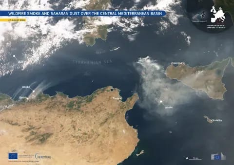
Copernicus Sentinel-3 satellites captured extensive wildfire smoke from Algeria and Saharan dust plumes simultaneously over the central Mediterranean basin. The fires caused significant casualties and generated large smoke plumes transported eastward, impacting the region.

Read the full story at EU Agency for the Space Programme →

← Back to News
AfrospatialMapping the World, Connecting Perspectives.

Read

  • Articles
  • News
  • African news
  • Magazine
  • Events

Company

  • About
  • Editorial standards
  • Write for us
  • Advertise
  • Partnerships
  • Contact

© 2026 Afrospatial Publishing.

PrivacyTerms