There is a key moment currently in Africa's cities as they continue to develop. Since Africa's cities are growing so quickly, people there face many exciting opportunities as well as difficult and complex challenges. Based on UN data from 2018, Austin, Texas, anticipates a threefold rise in its urban population within 35 years but growth is already happening more quickly in African cities, showing why fresh and flexible city planning is urgently needed.
Rapid changes in African cities are causing problems for old and insufficient infrastructure. Due to rapid population growth, roads are packed, poor communities have expanded outside the city, and both flooding and heat stress have become bigger problems. Using traditional methods, which are inflexible in their response, has proven time and again inappropriate for handling modern, complicated city situations.
GeoAI is the result of joining Geographic Information Systems (GIS) with the strength of Artificial Intelligence (AI). If cities apply all of these technologies, they can get great insights into where and how data is used and make better decisions. When AI and GIS are used together, urban planners and legislators can design more flexible, resistant, and equal cities by going beyond traditional, fixed forms of analysis.
The article shows how GeoAI is going to change the way urban areas in Africa are managed. We will analyze examples that reveal how it is being used, discuss the main hurdles that keep it from being widely adopted, and design a way to encourage responsible and for all.
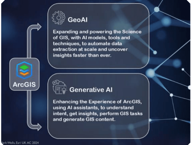
GeoAI brings a new idea for how cities use information. Using advanced techniques like those of machine learning, deep learning, and computer vision, GeoAI helps to discover more by analyzing data from different points. Unlike the fixed queries and inflexible maps of regular GIS sets, GeoAI uses automatic learning, analysis, and constant data review. With this approach, spatial data is now more responsive and useful in making better urban decisions (Janowicz et al., 2020). By connecting data to practical solutions, GeoAI can support African cities to handle fast expansion as well as form fairer, greener, and healthier cities for all people.
Key Uses of GeoAI:
- Forecasting future data sets for population lifts, the demand for infrastructure, or flood risks.
- Automatically spotting buildings, roads, plants, and water from images taken from space.
- Using mobile phone data, things like social media messages and data from sensors, together with geospatial information.
- Using Spatial Data in Real Time: Generating emergency responses and handling dynamic city management using ongoing monitoring of spatial data.
- As a result of its powers, GeoAI is ideally suited to tackle African city challenges since data is lacking, development is often unofficial and population growth is quick.
How GeoAI is used in African Cities
Planning for Floods and How to Deal with Disasters
We are seeing more flash floods in Accra, Kampala, and Dar es Salaam, leading to both deaths and harm to the infrastructure. A GeoAI system can make accurate flood risk zone models by using information about past rainfall, land use, the height of the land, and how water flows.
In Nairobi, the World Bank tested AI on satellite images and machine learning to map where water flows, so authorities could take action against risks in vulnerable locations (World Bank, 2021).
Keeping an Eye on Informal Settlements
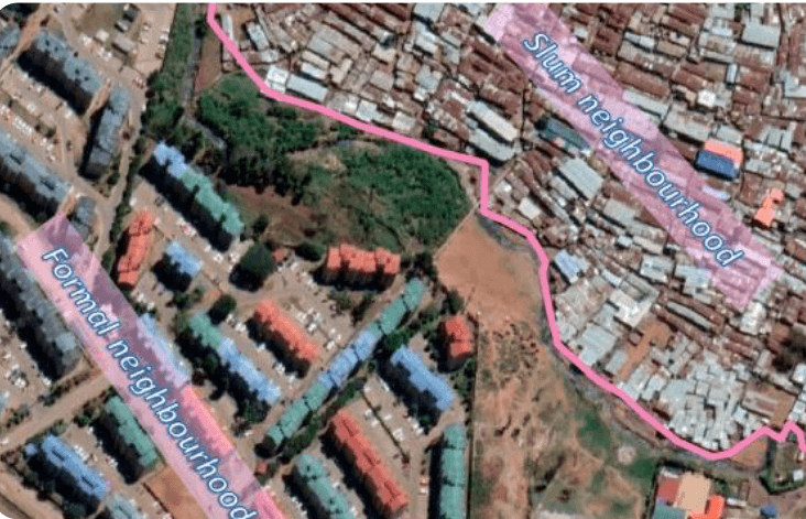
More than two-thirds of people living in cities in Africa reside in informal settlements, according to UN-Habitat in 2020. Because these areas aren't on official maps, it is hard to ensure services for residents and handle potential risks. With high-quality satellite photos, GeoAI makes it possible to spot, define, and track these settlements. A research team led by Du et al. (2019) showed that deep learning can accurately chart informal housing in Nairobi.
Condor Company is working on Smart Mobility and finding solutions for traffic optimization.
Long and crowded traffic is a constant concern in places like Lagos, Addis Ababa, and Johannesburg. GeoAI technology uses GPS, road networks, and data on traffic to help optimize traffic lights, suggest better public transport routes, and guide investment in infrastructure. AI-based study is assisting in Lagos by mapping how commuters use public transport and testing future scenarios by planning various changes in mobility services (Wang et al., 2021).
Resilience in Urban Climate
Risks from climate change are affecting cities in Africa, such as increasing temperatures, droughts, and rising sea levels. The use of GeoAI is increasing to model hot cities, anticipate water shortages, and provide support for green approaches to adaptation to the climate. In Accra, researchers combined satellite temperature information, detailed population counts, and maps of land cover to understand which areas are most at risk from heat.
The process of periodically collecting and studying data is known as Public Health Surveillance.
Using GeoAI, the field of epidemiology can improve its mapping and help health systems in times of disease outbreaks. When COVID-19 was spreading, African countries used spatial AI to identify where the disease was strongest and to improve where health resources were given out (Abdalla et al., 2021).
Reasons Why GeoAI Is Slow to Take Off in Africa
Even though GeoAI can greatly benefit African cities, its adoption is still being slowed by different problems:
- Data Limitations: Today, finding detailed and current spatial information presents a big challenge for many. Most cities rely on disconnected or aged datasets, and several have no geospatial infrastructure in place (Adelekan, 2016).
- Capacities for Technology and People: For GeoAI to work, you need experts in machine learning, data analysis, and mapping fields. But African urban planning departments face a major shortage of sufficient experts in town planning (UN-Habitat, 2020). A lack of these skills stops companies from innovating on their own, which results in them hiring external consultants.
- Problems With Separation Among Government Agencies: In a great number of African nations, geospatial data management is disorganized due to each agency operating on its own, which causes unnecessary duplication. Also, quite a few national or local governments are yet to create clear policies stating how AI should be used in city planning.
- Topics of Ethical and Equity Concern: If not applied in an inclusive way, GeoAI systems could support and continue to widen current disparities. If algorithms and information are unclear, if community input is missing, and data is biased, this can hurt the interests of vulnerable groups and reduce trust (Crawford, 2021).
Methods to Introduce GeoAI into Urban Development in Africa
GeoAI's potential can be achieved in Africa if governments and concerned parties use a well-designed strategy. The following advice gives you a clear path to follow:
Put money into Open Spatial Data Platforms. Creating and maintaining spatial data repositories that are free and easy to use should be a government priority. You can find useful templates on Digital Earth Africa and OpenStreetMap. Data digitization and standardization may be sped up with the help of academic institutions and the private sector.
Improve the Ability to Do Work on Equipment. Efforts to improve capacity should concentrate on helping urban planners, GIS technicians, and policymakers get familiar with AI and geospatial technologies. Higher education institutions should change their curricula to show how GIS and data science work together. Or, regional institutes that specialize in GeoAI could come into existence.
Make Sure GeoAI Policies Are Friendly. AI-driven spatial analysis should be specifically considered and given attention in urban planning and data governance polices. Governments are responsible for setting specific rules concerning data use, privacy, and how algorithms are used. Try to build relationships between different parts of society. For GeoAI to be successful, government, tech firms, society groups, and universities must work together. These hubs, labs, and partnerships can help develop solutions that can expand and succeed.
Foster a Society Targeting Everyone. GeoAI projects are successful in informal settlements if they involve the community and use data that reflects different people. Local communities should take part in creating maps, check the accuracy of AI outputs, and we need to build their capacity for AI work.
With GeoAI, African cities can deal with the many problems of urbanization quickly, smartly, and fairly. With its features for flood planning, diagramming of informal areas, and mobility and climate assistance, GeoAI gives cities helpful solutions for urban management. To make this potential happen, we need to keep investing in data systems, increase technology knowledge, make policies match up, and focus on design for all.
The future of Africa's cities has yet to be determined—there are many possibilities waiting to be discovered and used. GeoAI is helping the continent overcome the problems associated with traditional city planning. By using GeoAI, data-based choices can be made, maps are updated instantly, and forecasting becomes possible, all to help African cities develop. Using these advanced tools, Africa can jump over past issues with planning and designing city spaces that are inclusive and fit the wide range of needs of its population.
It goes beyond thinking about smart cities. We are aiming to advance urban spaces that are just, equitable, and strong. It means planning cities that can expand with growing populations and are better for everyone's health, environment, and chances of finding work. There is access to important services, environmental protection, and lively, secure communities in the reimagined urban world.
As such, Africa's experience with urban growth may guide others worldwide, showing how carefully choosing and using new technologies can make cities that are both smart and centered on people, the environment, and the economy. Rather than having a fixed future, we are all contributing to a story that can see Africa set examples of strong cities and inspiring advancements built around their communities.