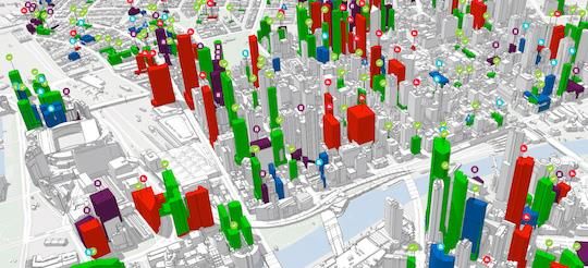
As I author this article, many Cities and Urban setups have failed due to inappropriate planning and Urban Planning practices. Before I delve into the use of Geographic Information Systems (GIS) in Urban Planning, it is crucial to understand the concept of Urban Planning. Urban Planning is the management and coordination of the construction of built-up areas for improving human living standards in habitable, effective, and aesthetically pleasing environments.
The technology of GIS is very crucial and needed in urban, as it provides substantial functionality to handle spatial data to support decisions made in the Planning process. This article extends further in explaining how GIS is utilized in Urban Planning, constituent, role, use, and value.
GIS hardware hereby refers to the equipment used to run GIS software and handle spatial data. This commonly includes computers, servers, GPS devices, and other mobile data collection devices. Stable hardware is employed because it is important to handle big data and have effective methods for computations. The technologies associated with GIS provide the tools needed for gathering, archiving, accessing, processing, and visualizing geographical information.
- ArcGIS: One of the most comprehensive integrated software applications that improve spatial analysis and mapping tools.
- QGIS: An open-source GIS software, which is considered by many to be extremely flexible and modular due to a plugin system.
- Google Earth: They are also used in the production of maps that display geographical information across the globe. GIS is based on two forms of information: spatial information (which can be places, forms, and structures) and attribute information (which provides extra information about spatial information).
- Remote Sensing: Second, using satellite imagery and aerial photographs as tools for data collection and analysis. Surveys: Primary data was collected from a survey through GPS devices and total stations.
- Existing Maps and Databases: Geospatial references, and other references that include topographic maps, cadastral information, and other demographic databases. This means that data analysts or scientists, urban planners, policymakers, or even any other member of the community can apply GIS.
Therefore, the right GIS implementation is grounded on the ability to ensure a sufficient number of highly skilled staff can analyze the spatial data and apply them to tackle issues facing Urban Planning and Development. The methods component is the procedures and techniques used to operate and analyze GIS data. This encompasses Spatial Analysis, Modeling, and Statistical Techniques that are quite unusual in handling various Urban Planning issues.
Several roles of GIS include assisting in the collection, storage, and analysis of both spatial and non-spatial data about Urban Areas. This aspect makes GIS useful in planning because it synthesizes data from various fields and presents Planners with the bigger picture. Among the spatial analysis techniques in GIS that can be employed by Urban Planners to describe relations, patterns, and trends at the city level include;
- Proximity Analysis: Defining how near or far one feature is from the other features that might encompass schools, hospitals, and residential units.
- Overlay Analysis: placing one or more maps on top of another to emphasize some areas of concern or interest such as areas prone to floods and regions that experience high rates of criminal activities.
- Network Analysis: Deciding on which strategies should be followed by the transportation systems, taking into account traffic and coverage.
GIS in Waste Management
Geographic Information Systems mapping is essential in waste management because it provides a clear picture of waste generation patterns, collection routes, and potential disposal sites. This visual understanding helps optimize collection schedules, minimize transportation costs, and identify areas for improved waste management infrastructure. By analyzing data on waste hotspots and flow patterns, Urban Planners can develop efficient waste management strategies, reduce environmental impact, and promote sustainable waste management and disposal practices.
GIS in Visualization, Modelling and Simulation
Another aspect of GIS is visualization. This is key because GIS assists Planners in creating a mirror of the environment based on various aspects in the form of maps and models. When key constituencies and audiences consume and decode information, the method of representation offers value in the way that it creates a surface for the exchange of ideas and cooperation. As such, GIS is effective in the modeling and simulation of Urban Systems where a Planner can try out different scenarios and see the outcome. For instance, they can use the model to predict the impact of population growth on the amount of infrastructure to be used or the impacts of zoning alteration on land utilization.
This again can play an important role in the decision-making process by presenting the bits of information in the form of recommendations and suggestions supported by the available spatial data. The analysis can be applied to potential development plans, assess impacts on the environment, prioritize projects, and more.
GIS in Land Use Planning and Zoning
What is the Basic Geographical Information System when incorporated into Urban Planning? Agricultural land management is an activity in the field of Land Use Planning that aims at the division of and use of the land among the various sectors of development such as residential, commercial, industrial, and recreational. GIS assists Land Use Planning by Analyzing Land Suitability, which evaluates the chances for the development of some territory according to the type of soils, reliefs, and position to communication. Zoning assists in identifying a checklist that would indicate which areas are suitable to be provided with structures and outlining the set of regulations to be used in the process of the development of those areas based on the current type of land uses in the regions.
GIS is very useful in observing change by monitoring the developmental changes in land utilization, evaluating the impacts of planning policies that have been implemented, and detecting new trends. Appropriate end-use of the infrastructures ensures an increased durability of built-up areas and service provision. GIS also plays a vital role in infrastructure planning and management, the application of GIS in infrastructure planning and management can be described as follows:
- Infrastructure Networks to be mapped: These are important in locating on the map roads, utilities, public transport facilities, and green areas. This can be used to show that some areas seem to lack these important infrastructures to plan how to distribute resources for proper development of the area and to ensure that attention is paid to such areas that do not seem to have any proper road network for transportation and other utilities
- Analyzing Demand: Regarding the number of infrastructural services needed today and in the future concerning population and several activities that occur on different pieces of land.
- Asset Management: Synchronization of measurements in terms of observing the usage and depreciation of infrastructural assets based on their useful economic life. In this process, various conditions for further development of the urban territory are weighed with the necessity to preserve the environment.
GIS serves the purpose of environmental management in the following ways:
- Assessing Environmental Impacts: Taking into account the potential impacts of development projects on natural resources and environments in regards to the measure of bio-diversity value.
- Identifying Risk Zones: Conducting assessment on geographic areas prone to risks from natural disasters such as floods, landslides, or erosion to plan and design adequate mitigations and other sustainable measures and practices.
- Conservation Planning: This capacity allowed for estimating and ranking species and ecosystems according to their significance and consequently, choosing targets for conservation.
GIS in Transportation
Transportation systems are the main instruments in making society more mobile or less congested, and hence, more affluent. The following are some of how GIS aids in transportation planning:
- Analyzing Traffic Patterns: Identifying features of the traffic and congestion to define the existing vulnerabilities and potential sources of traffic improvement.
- Optimizing Public Transport: Ensuring that the everyday itineraries and operational timetables of public transport services cover as many people as possible.
- Evaluating Connectivity: Assessing the integration of different types of transport networks and potential ways to enhance and develop them.
GIS in Public Engagement
This is because the participation of the individuals is highly encouraged more so when it comes to identifying the needs of the urban areas and coming up with a way of meeting such requirements. Integrating GIS into the Planning and decision-making process and promotes public participation in the following ways:
- Providing Interactive Maps: Offering a scenario whereby the citizens can employ technological tools to comprehend planning proposals or even engage in an active survey.
- Facilitating Transparency: Relaying the planning information and data of the company to the public in an endeavor to make the company more transparent.
- Supporting Collaborative Planning: Creating interactivity of planners, stakeholders, and the community to create multiple possibilities for further expansion of cities. GIS is therefore a very important tool in Emergency Planning and Management practices to offset or prevent the loss of an urban area in case of disaster.
- Risk Assessment: Using G. I. S in determining risk avoidance areas vulnerable to natural and other anthropogenic disasters.
- Evacuation Planning: Assessment of the number of refugee areas and evacuation corridors based on physical characteristics and population density in the danger areas.
- Resource Allocation: Delivery of emergency products and services in a bid to ensure that the cases are dealt with as required.
The benefits of GIS in urban planning
- Decision-making: Here, GIS contributes to the correct decision-making within a short time based on data typical for the modern urban environment. In this way, the Planner secures a good number of choices in which he can reason and work where it is required and necessary without jeopardizing and possibly offering a raw deal to the country and its people.
The benefits it has include that the GIS software does most of the Planning aspect because; it is useful in the collection of data, analysis of data, and presentation of data. That reduces time, it also releases a lot of time for the Planners and other individuals who are involved in the Planning as well as do lots of planning and formulation of Planning policies.
- Collaboration: The major advantages that GIS has over other systems include the fact that it fosters interconnectivity between the different departments of an organization, and other stakeholders who may be involved in a particular project or members of a community associated with the GIS. This increases the chances of having a strong approach to Urban Planning since the different views of people are taken into consideration.
- Transparency: As a result, GIS transcends barriers and contributes to Planning data dissemination, thereby enhancing the degree of accountability to the public. They get a chance to collect information on various projects and changes in the zones and the development of the infrastructure that the citizens should actively take part in Planning.
- Better resource management: It makes it easy for planners to identify areas of shortage or lack of amenities and, therefore, ensure that necessary resources are channeled towards such regions. This ensures that the available scarce resources will be well utilized in the overall management of society to have the best results.
- Sustainable Development: GIS in Planning incorporates Environmental, Social as well as Economic perspectives in such a way that it would increase Sustainable Development. Thus, the impact of development on resources and communities will be identified, and the cities for habitation that are Sustainable, Sufficient, and Environment-friendly can be planned
Conclusion
Technology in the form of Geographic Information Systems has enhanced Urban Planning by making it possible to analyze spatial data; display features and patterns, and justify planning decisions. Cities are rapidly expanding and developing, they are likely to experience challenges like climatic change, resource constraints, and high pressure regarding human population, GIS will remain an indispensable tool in the development of sustainable and resilient cities. With the help of GIS, Urban Planners and Landscape Architects can implement mechanisms for creating comfortable Urban Environments, which, at the same time, protect the interests and opportunities of the next generation.