
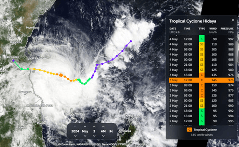
The recent path of Cyclone Hidaya, which struck Tanzania but was too weak to significantly impact Kenya, highlights the intricate dynamics of cyclone formation and movement. Understanding these powerful natural phenomena involves exploring their origins, development stages, and the crucial factors influencing their strength and direction.
A cyclone is a large rotating air mass formed over warm ocean waters due to low atmospheric pressure. Cyclones originate from a process called cyclogenesis, which occurs in tropical regions between the Tropic of Cancer in the Northern Hemisphere and the Tropic of Capricorn in the Southern Hemisphere. These regions are characterized by vertical, direct, and high solar radiation.
Different Names for Tropical Cyclones
Tropical cyclones are known by different names depending on the region:
- Cyclone – Indian Ocean region
- Typhoon – Northwest Pacific region
- Hurricane – Northeast Pacific and Atlantic regions
How Do Cyclones Occur?
Meteorologists categorize the development of tropical cyclones into four stages:
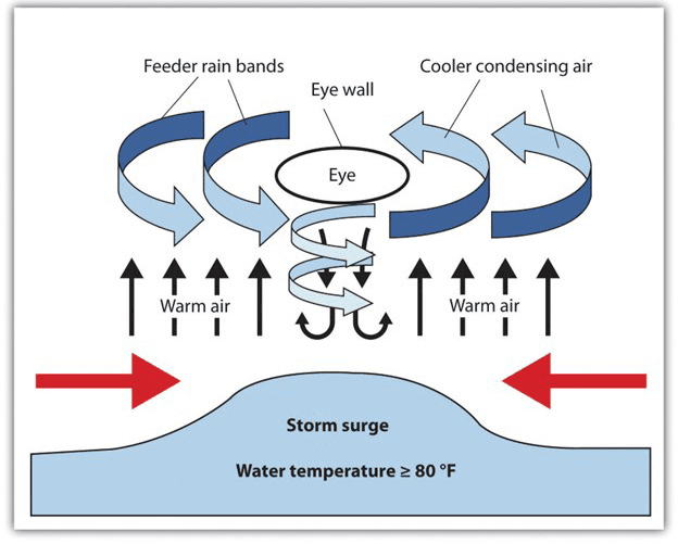
Tropical Disturbance: Evaporation from sun-heated water surfaces (above 26.5°C) initiates the process. Rising water vapor cools, condenses into clouds, and releases heat, creating a self-perpetuating loop with a low-pressure zone at the surface. This leads to a disorganized cluster of thunderstorms with weak circulation.
Tropical Depression: The system becomes more organized, with wind speeds between 23-38 mph (37-61 km/h) and a distinct low-pressure center at the surface. Favorable conditions like warm water, low wind shear, and supportive atmospheric conditions are critical for further development.
Tropical Storm: Wind speeds increase to 39-73 mph (63-118 km/h), and the storm gains a well-defined low-pressure center and swirling circulation. These storms bring heavy rain and potential flooding, often leading to weather warnings and preparations. Tropical storms can intensify into hurricanes, typhoons, or cyclones, or they may weaken and dissipate.
Hurricane/Typhoon/Tropical Cyclone: These mature systems have winds exceeding 74 mph (119 km/h). The Saffir-Simpson Hurricane Wind Scale categorizes them based on wind speed, with Category 5 being the most catastrophic, featuring winds exceeding 157 mph (252 km/h). These storms unleash powerful winds, storm surges leading to coastal flooding, heavy rain triggering inland flooding, and even tornadoes.
Wind Movement
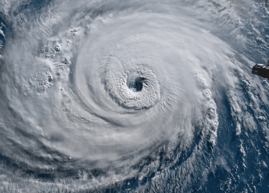
Sunlight warms the ocean surface, causing the air above to rise and create a low-pressure zone. Cooler air from surrounding areas is drawn in, heated, and rises, creating a continuous circular motion. This process forms the characteristic “eye” of the cyclone, a calm region amidst the surrounding storm’s fury.
The Coriolis Effect
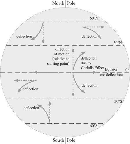
Earth’s rotation adds a twist to cyclone winds through the Coriolis effect. Imagine a ball thrown outwards on a spinning merry-go-round – it appears to curve due to the rotation, even though its path is straight relative to the thrower.
Similarly, rising air in a cyclone experiences an apparent deflection due to Earth’s spin. This deflection, to the right in the Northern Hemisphere and left in the Southern Hemisphere, creates a low-pressure center that acts like a vacuum, sucking in surrounding air. As this air spirals inwards, the Coriolis effect and the narrowing path cause it to accelerate, resulting in the powerful, characteristic winds of a cyclone. The Coriolis effect itself doesn’t create the wind but orchestrates the swirling circulation that fuels the cyclone’s growth and destructive power.
Landfall: A Turning Point for Cyclones
Landfall presents a critical juncture for a powerful cyclone, transforming it from a swirling behemoth at sea into a potential harbinger of destruction for coastal communities. However, the cyclone’s fate hinges on a crucial factor: its access to moisture, the very lifeblood that fuels its growth.
When a cyclone makes landfall, it loses its primary moisture source – the warm ocean surface. This loss weakens the rising warm air and the associated low-pressure zone at the cyclone’s center, leading to a rapid decline in strength. The rough terrain of landmasses further accelerates this weakening process through increased friction. Smaller cyclones with limited internal moisture reserves are more vulnerable to rapid weakening compared to larger ones. The presence of landforms like mountains can also disrupt a cyclone’s circulation, hastening its demise.
The Coriolis Effect and Cyclone Formation: Why Hidaya Bypassed Kenya
The path of Cyclone Hidaya underscores the influence of the Coriolis effect on cyclone development. Cyclones rarely form near the equator due to the weak Coriolis effect. This effect is caused by Earth’s rotation, which plays a vital role in deflecting winds and initiating the swirling circulation that fuels cyclones. At the equator, Earth’s rotation has minimal east-west deflection due to its alignment with the rotational axis. This weak Coriolis effect is insufficient to create the sustained swirling motion needed for a cyclone to form.
Cyclone formation thrives in zones with a stronger Coriolis effect, typically between 5 and 30 degrees latitude (both north and south of the equator). This zone offers the right balance between warm ocean temperatures (fuel for the storm) and a strong Coriolis effect to initiate and sustain the swirling circulation.
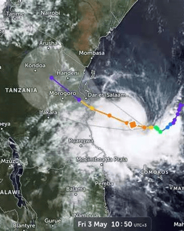
In the case of Cyclone Hidaya, Kenya’s proximity to the equator likely placed it in a region with an insufficient Coriolis effect to support significant cyclone development. Conversely, Tanzania, located further south, offered more favorable conditions for cyclone formation due to a stronger Coriolis effect in its waters. This explains why Cyclone Hidaya bypassed Kenya and struck Tanzania.